 GTA 6 Map
Cottonmouth Lake
WaterGrassriversGrid K5
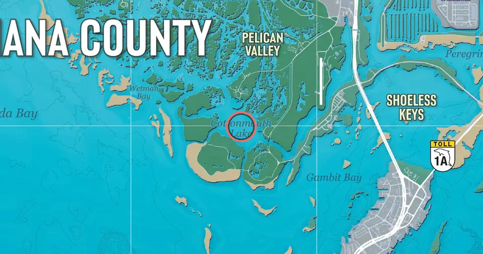
Cottonmouth Lake is a body of water in the Grassrivers region. It is named on Rockstar's official map of Leonida, the setting of Grand Theft Auto VI.
On the map's grid it falls in cell K5, 4.6 miles east and 10.0 miles south of the north-west corner. One grid cell is one mile. The nearest named place is Pelican Valley, 0.47 mi (0.75 km) to the north.
Within half a mile of the name, the official map shows about 50% water, 35% woodland and 10% open or green land. It sits by the water. The nearest highway marker printed on the map is State Route 1A (toll), 1.35 mi to the south.
How far is Cottonmouth Lake from the main hubs?
- Cottonmouth Lake is south-west of Downtown Vice City3.57 mi · 5.74 km
- Cottonmouth Lake is south of Vice City International Airport2.63 mi · 4.24 km
- Cottonmouth Lake is south of Port Gellhorn5.71 mi · 9.19 km
- Cottonmouth Lake is south of Ambrosia5.42 mi · 8.72 km
- Cottonmouth Lake is north-west of Key Lento1.03 mi · 1.66 km
- Cottonmouth Lake is south-east of Grassrivers1.48 mi · 2.39 km
- Cottonmouth Lake is south of Mount Kalaga National Park7.11 mi · 11.4 km
Nearest of each kind
- Town or city: Key Lento1.03 mi south-east
- Airport: Henry J Edwards Airport2.03 mi north-west
- Landmark: Paradise RV Park1.21 mi north
- Beach or island: Shoeless Keys0.92 mi east
- Water: Gambit Bay0.56 mi south-east
- Park: Courtland Park2.69 mi north-east
- Sports venue: Boone Speedway0.97 mi north
- Industrial site: T.H. Power Station1.36 mi north-east
Cottonmouth Lake is the only named place in grid cell K5.
Places near Cottonmouth Lake
- Pelican Valley0.47 mi · 0.75 km north
- Gambit Bay0.56 mi · 0.91 km south-east
- Shoeless Keys0.92 mi · 1.48 km east
- Boone Speedway0.97 mi · 1.56 km north
- Pelican River0.99 mi · 1.60 km north-west
- Key Lento1.03 mi · 1.66 km south-east
- Hamlet1.17 mi · 1.88 km north-east
- Paradise RV Park1.21 mi · 1.95 km north
Distances are straight lines measured on the map. Positions mark where the official map prints each name.