 GTA 6 Map
Atlantic Ocean
WaterGrid E9
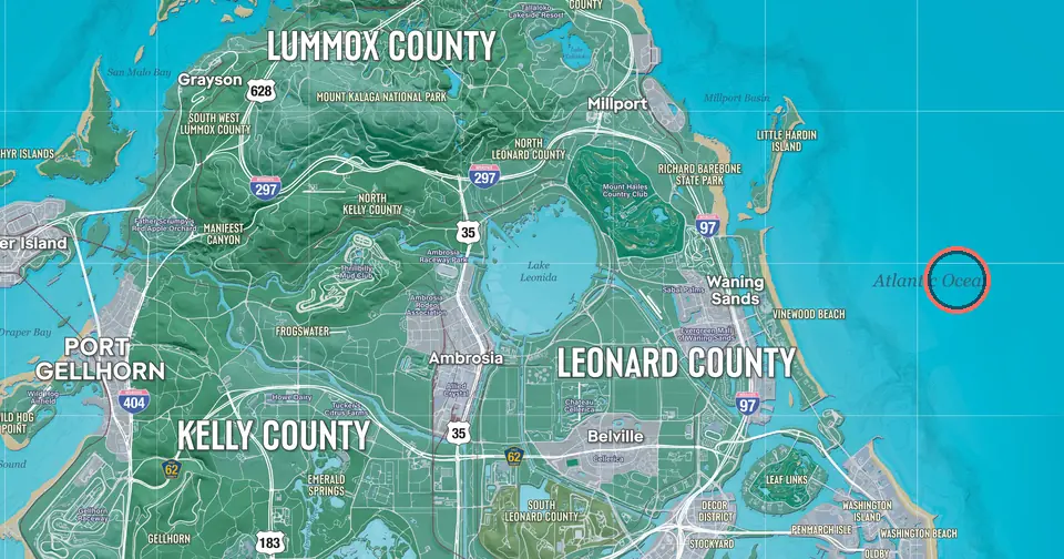
Atlantic Ocean is a body of water in the waters around Leonida. It is named on Rockstar's official map of Leonida, the setting of Grand Theft Auto VI.
On the map's grid it falls in cell E9, 8.3 miles east and 4.1 miles south of the north-west corner. One grid cell is one mile. The nearest named place is Vinewood Beach, 1.00 mi (1.61 km) to the west.
Within half a mile of the name, the official map shows open water.
How far is Atlantic Ocean from the main hubs?
- Atlantic Ocean is north-east of Downtown Vice City3.38 mi · 5.44 km
- Atlantic Ocean is north-east of Vice City International Airport4.56 mi · 7.34 km
- Atlantic Ocean is east of Port Gellhorn5.57 mi · 8.97 km
- Atlantic Ocean is east of Ambrosia3.26 mi · 5.25 km
- Atlantic Ocean is north-east of Key Lento7.45 mi · 12.0 km
- Atlantic Ocean is north-east of Grassrivers6.21 mi · 10.00 km
- Atlantic Ocean is east of Mount Kalaga National Park3.97 mi · 6.39 km
Nearest of each kind
- Town or city: Waning Sands1.46 mi west
- Airport: Vice City International Airport4.56 mi south-west
- Landmark: Evergreen Mall of Waning Sands1.69 mi west
- Beach or island: Vinewood Beach1.00 mi west
- Water: Millport Basin1.88 mi north-west
- Park: Richard Barebone State Park1.83 mi west
- Sports venue: Leaf Links1.72 mi south-west
- Industrial site: Port Vice City3.24 mi south
Atlantic Ocean is the only named place in grid cell E9.
Places near Atlantic Ocean
- Vinewood Beach1.00 mi · 1.61 km west
- Little Hardin Island1.44 mi · 2.32 km north-west
- Waning Sands1.46 mi · 2.34 km west
- Washington Island1.63 mi · 2.62 km south
- Washington Beach1.68 mi · 2.71 km south
- Evergreen Mall of Waning Sands1.69 mi · 2.71 km west
- Leaf Links1.72 mi · 2.77 km south-west
- Sabal Palms1.80 mi · 2.89 km west
Distances are straight lines measured on the map. Positions mark where the official map prints each name.